Earthquake - generated tsunami.
Earthquakes are a tsunami - generating process because sudden slip on a fault plane beneath or close to a water body such as the ocean will, unless the movement vector is exactly parallel to the ocean floor, cause the ocean floor to move up or down (or, commonly, both as discussed below) and thus also displace the sea or ocean surface up or down. The amount of movement depends on the magnitude of the earthquake (hence the amount of coseismic slip on the generating fault zone and the area of movement); the geometry of the fault zone and direction of movement upon it; and the focal depth of the earthquake below the surface.
DIAGRAM ILLUSTRATING BASIC FAULT FEATURES
Earthquake size and tsunami size.
Earthquake magnitude is expressed in various ways, most of which are strictly speaking measures of the response of seismometers to the earthquakes. The most fundamental measure of earthquake size is however the Moment Magnitude MW, which is a function of the seismic moment M0, or the energy released in the earthquake as motion of the moving rock masses: in order to estimate it accurately it is necessary to measure seismic energy over a wide frequency range, down to 0.01 Hz (corresponding to seismic waves with a period of 100 seconds), or else carry out detailed geophysical, geodetic and geological studies to independently estimate the earthquake parameters on which it depends.
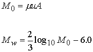
M0 varies as a function of the average amount of movement on the fault surface in the earthquake, u, the area of fault surface on which movement occurs, A, and the shear modulus of elasticity m , a measure of how much force is required to elastically deform the moving rock on either side of the fault:
The shear modulus of elasticity varies only by a little more than a factor of two for most rocks in the crust and upper mantle where earthquakes occur. This means that seismic moment varies mostly as a function of the amount of movement and the area over which it occurs; and furthermore, since the relationship between these two is governed primarily by the "stiffness" of the rock (which is expressed largely in terms of the shear modulus of elasticity) and thus the permitted gradients in displacement along the fault surface, a relatively simple relationship exists between seismic moment and the area and amount of fault slip. It is therefore to be anticipated that a simple relationship will also exist between the seismic moment of an earthquake and the size of tsunami that it can directly produce, provided that due allowance is made for geometrical and depth effects as discussed below. As general rules, only earthquakes with MW ³ 6.5 - 7 produce significant tsunami directly (although smaller earthquakes may trigger submarine landslides, as discussed below) and the largest earthquakes (MW » 9), since they almost invariably occur at the margins of oceans for reasons discussed below, normally produce major tsunami that cause significant damage over wide regions.
Unfortunately, this does not mean that the tsunami - generating potential of an earthquake can be quickly and simply evaluated from near - real - time seismic records, for example for warning purposes, even though rapid processing of records from a number of seismometers allows estimates of the geometrical and (to a lesser extent) depth effects discussed below. The reason for this is that most seismometers are relatively short - period instruments and only measure the higher - frequency components of the seismic energy radiated by an earthquake. In reality, a large part of the seismic energy of earthquakes is released at frequencies of 0.01 Hz or less. As a result the various instrumental estimates of earthquake magnitude such as surface- and body- wave magnitudes, although they provide good measures of expected intensities of ground shaking, do not provide good estimates of the values of A and u, and thus the tsunamigenic potential of earthquakes. About 1 in 10 submarine earthquakes produce tsunami that are 10 to 100 times larger than expected from their instrumentally - estimated magnitudes: notable examples include the 1st April 1946 earthquake off Alaska, which produced a tsunami that devastated large parts of Hilo, Hawaii despite having a surface - wave magnitude MS of only 7.4. Conversely, other large earthquakes produce much smaller tsunami than expected, leading to "false alarm" problems for tsunami warning systems.
Some of these "tsunami earthquakes" are in fact likely to have been relatively small earthquakes which triggered submarine landslides, as discussed below, but many others are likely to have been "slow" or "silent" earthquakes in which comparatively slow propagation of the rupture along the fault surface led to only a tiny fraction of the seismic energy being released at high frequencies whilst all the rest was emitted at low frequencies that cannot be detected by normal seismometers. Recent studies suggest that this type of earthquake tends to occur at shallow depths in subduction zones where thrust faults (see below) cut weak, partly ductile sediments in which fault ruptures do not propagate rapidly but the low stiffness allows for unusually large slips in relation to the size of the fault rupture: they may therefore have a specific regional distribution which is discussed further below (SECTION NUMBER?). The complex relationship between instrumental estimates of earthquake size, moment magnitudes of earthquakes, and their tsunamigenic potential makes it difficult to use conventional earthquake catalogues to accurately predict tsunami hazard levels, and has also led to efforts to do the reverse, that is to say make estimates of earthquake magnitude using tsunami records (see discussion of tsunami magnitude scales below).
Earthquake geometry and tsunami size.
The slip direction of earthquakes varies with the type of faults on which they occur, and consequently there is not a simple relationship between the amount of slip on the fault surface during an undersea earthquake and the amount of vertical displacement of the sea bed that results. For the purposes of understanding tsunami generation earthquakes can be divided into the following categories, each with its own characteristic tsunamigenic efficiency. It should however be borne in mind that most earthquakes are more or less oblique - slip events, intermediate between the "end - members" shown in FIGURE:
(FIGURE WITH BLOCK DIAGRAMS SHOWING DIFFERENT EARTHQUAKE GEOMETRIES, FAULT SCARP TYPES ETC.)
Normal - fault
Earthquakes are characteristic of regions of extension such as Greece and the Aegean Sea, and the Red Sea. They occur on steeply - inclined faults and involve downward movement of the hanging - wall block (that above the fault surface). The slip vector, which defines the direction of movement, is vertical or near- vertical. The vertical movement of the surface around the fault is therefore comparable to the total displacement provided the fault is close to the surface (see below), and such earthquakes can therefore be efficient tsunami sources. They are, however, usually relatively small earthquakes and have produced few major tsunami except by triggering of landslides on the steep fault scarps.
Reverse - fault
Earthquakes also occur on steeply - inclined fault surfaces and involve near - vertical movements, but with the opposite sense of motion ( the hanging - wall moves upwards) and therefore occur in regions of compression and tectonic plate convergence. The earthquake and tsunami of 1st November 1755, which destroyed Lisbon and Cadiz, is likely to have involved movement on a reverse fault although its precise location is still controversial.
Thrust - fault
Earthquakes are a specific type of reverse fault in which compressive or convergent motion occurs on a low - angle or shallowly - inclined fault. Such faults form the boundaries of the subducting plates around the Pacific rim. Although the slip - vector is inclined at only a small angle to the sea surface two factors make these the most important source of earthquake - generated tsunami. Firstly, thrust - fault earthquakes at subduction zones are the largest earthquakes of all. Secondly, the submarine slope above the thrust fault is usually inclined at an angle of 10 - 25° and so the horizontal component of motion on the fault translates into a significant vertical movement of the seafloor beneath any one point. Thirdly, flexing of the crust above the thrust faults in the largest earthquakes commonly leads to subsidence at the coast which exacerbates the effects of the tsunami as discussed below for the example of the 1964 Alaska earthquake.
Strike - slip fault
Earthquakes involve near - horizontal movements and are therefore extremely inefficient at producing tsunami directly, although they may trigger submarine landslides. The lateral movements on these faults often juxtapose areas of very different water depth across very steep fault scarps, making such landslides both more common and more efficient in tsunami generation.
The nature of the deformation in a given region, and therefore the dominant earthquake geometries which occur in it, is therefore critical to the level of the earthquake - generated tsunami hazard.
Earthquake depth and tsunami size.
Even when earthquakes involve near - vertical movements, the movement of the surface above them is commonly much less than the movement on the fault itself. This is because the fault rupture may not extend to the surface, and the movement on the fault is cushioned by permanent, distributed deformation of the rocks around it (FIGURE). Even in the case of surface - rupturing faults, the maximum surface displacement is on average only half of the maximum sub - surface displacement because displacement on faults decreases smoothly from the centre of the fault to the edges (FIGURE).
FIGURES (THUMBNAIL SKETCHES) SHOWING SURFACE DISPLACEMENTS ASSOCIATED WITH NORMAL FAULTS AT DIFFERENT DEPTHS AND DISPLACEMENT GRADIENTS ON ONE FAULT.
As a result of this deeper earthquakes with foci at depths of a few tens of kilometres or more, which include many of the largest and most widely - felt earthquakes, are much less efficient tsunami sources than near - surface earthquakes. Any estimate of tsunami hazard based on earthquake catalogues must therefore also include correction for earthquake focal depth distributions.
Earthquake - generated seiches
As noted above, most earthquake - generated tsunami are produced in the immediate vicinity of earthquakes beneath the sea or ocean. However, enclosed bodies of water such as lakes and lagoons sometimes experience tsunami - like water level oscillations, known as seiches, at great distances from earthquakes. These are caused when the seismic waves radiating out through the Earth from the earthquake source vibrate the water body at a frequency equal to one or more of its natural oscillations (related to the time it takes a wave to travel across the lake): although these fluctuations are typically only a few metres in height they can cause significant damage to property since this is often built very close to the normal level of these enclosed water bodies. The 1964 Alaska earthquake caused significant seiches in lakes as far south as Texas.
The maximum size of earthquakes and earthquake - generated tsunami
The largest observed earthquakes (MW » 9 to 9.5) typically involve average slips of about 10 m over fault slip areas of about 100 000 km2 (typically 700 - 1000 km long by 100 - 150 km wide, since the depth of the seismogenic zone in the earth limits the width), and the limits imposed by the structure of the earth and the lengths of individual faults mean that it is unlikely that an earthquake much larger than these will ever occur. Furthermore, these earthquakes occur at subduction zones, where the seismogenic layer is thickest, and therefore typically have a thrust type geometry which is an efficient generator of tsunami waves. It is therefore likely that the tsunami generated by the largest observed earthquakes, such as those produced in the 1960 Chile and 1964 Alaska earthquakes, are about as large as will ever be produced directly by an earthquake.