Using Satellite Thermal Infra-Red
Imagery to Study Boundary Layer Structure in an Antarctic
Katabatic Wind Zone
M.J. Varley,
T.A. Lachlan-Cope
and J.C. King
We have used snow surface temperatures obtained from thermal
infra-red satellite imagery gathered under cloud-free conditions,
together with radiosonde profiles of free-air temperature and
high-resolution topographic data to study the thermal structure
of the atmospheric boundary layer inland of
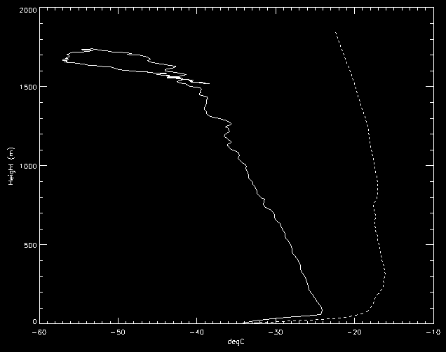
Halley Research Station Surface temperatures over the
Brunt Ice Shelf are significantly lower than those observed on
the lower part of the adjoining coastal slopes as a result of the
strong surface temperature inversion that forms over the ice
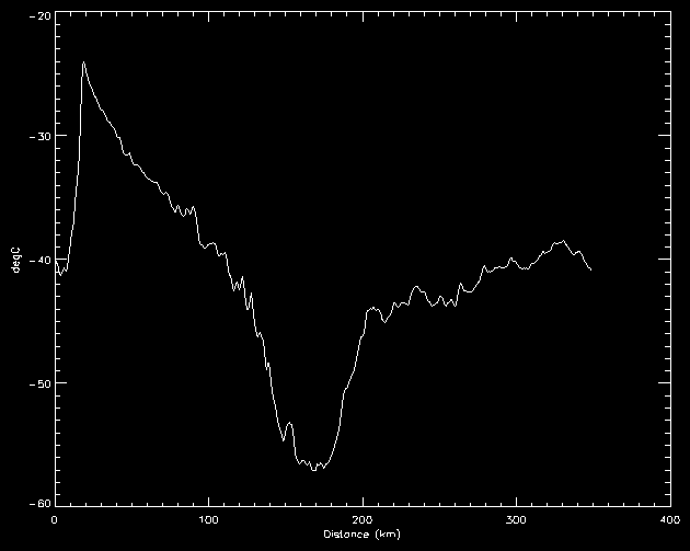
shelf. Between 400 and 1500 m elevation the surface
temperature lapse rate is close to the dry adiabatic value while
the free-air temperature profile shows significant stability over
this height range. This appears to imply that the strength of the
surface inversion increases with increasing elevation. Above
1500 m the surface temperature lapse rate becomes significantly
superadiabatic and the coldest surface temperatures are found a
few tens of kilometres inland of the highest topography. We
believe that this technique may prove useful for studying
boundary layer structure in other regions of Antarctica where
both high resolution topographic data and suitable satellite
imagery are available.
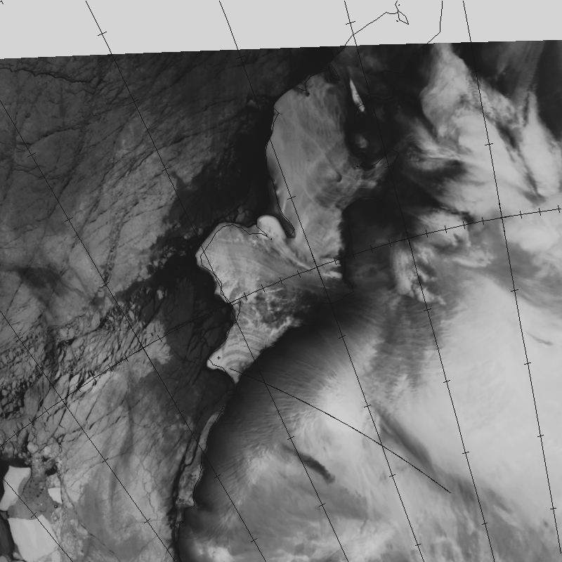
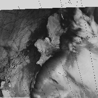 This (105 Kb) is a
NOAA AVHRR channel 4 image of the Brunt Ice Shelf and
Coats Land at 0723 UTC on 2 August 1995, obtained using the
ARIES satellite reception facility at
Rothera Research Station. Halley Research Station is marked with a cross. A larger version of
the image (380K) is available here .
This (105 Kb) is a
NOAA AVHRR channel 4 image of the Brunt Ice Shelf and
Coats Land at 0723 UTC on 2 August 1995, obtained using the
ARIES satellite reception facility at
Rothera Research Station. Halley Research Station is marked with a cross. A larger version of
the image (380K) is available here .
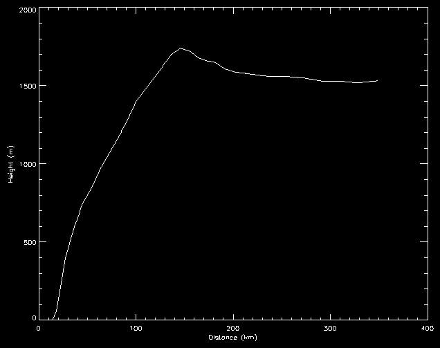
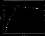 |
A topographic section along the line marked on the image. |
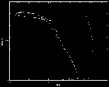
 |
The surface temperature profile along the section line. |
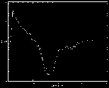
 |
The surface temperature (solid line) and the free-air temperature (broken line - from a
radiosonde ascent at Halley) as
a function of height. |
Points to note include:
- The low-level inversion in both surface and free-air temperatures
- The near adiabatic lapse rate of the surface temperature between 400 and 1500 m
- The stability of the free-air profile over this height range
- The superadiabatic lapse rate in surface temperature on the upper part of the slope
This study forms part of the Coats Land Mesoscale Project
Return to the Main boundary-layer page
Page produced by John King
 This (105 Kb) is a
NOAA AVHRR channel 4 image of the Brunt Ice Shelf and
Coats Land at 0723 UTC on 2 August 1995, obtained using the
ARIES satellite reception facility at
Rothera Research Station. Halley Research Station is marked with a cross. A larger version of
the image (380K) is available here .
This (105 Kb) is a
NOAA AVHRR channel 4 image of the Brunt Ice Shelf and
Coats Land at 0723 UTC on 2 August 1995, obtained using the
ARIES satellite reception facility at
Rothera Research Station. Halley Research Station is marked with a cross. A larger version of
the image (380K) is available here .