CLAMP - The Coats Land Mesoscale Project
Introduction
The Coats Land Mesoscale Project (CLAMP) aims to study the
generation, propagation and dissipation of katabatic winds on
the ice slopes inland of Halley Research Station. In order to
achieve this aim, a line of automatic weather stations (AWSs) has been
established stretching up the slopes inland of Halley to the
highest part of Coats Land, about 200 km south of the station.
In addition to these year-round surface measurements, we hope
to obtain some information on the vertical structure of the
boundary layer in this region using tethersondes carried by kites. We are also using
infra-red satellite imagery to study boundary-layer
structure in this region.
The CLAMP stations
 A map showing the station locations
Location: 75 ° 35' S, 26 ° 19' W
Elevation: 36 m
Measurements:
AWS CLAMP 1
Location: 75 ° 53' S, 25 ° 30' W
Elevation: 34 m
Measurements:
- Wind speed and direction
- Temperature and humidity at two levels
- Pressure
AWS CLAMP 2
Location: 75 ° 58' S, 25 ° 24' W
Elevation: 403 m
Measurements:
- Wind speed and direction
- Temperature and humidity at two levels
- Pressure
AWS CLAMP 3
Location: 76 ° 42' S, 24 ° 32' W
Elevation: 1454 m
Measurements:
- Wind speed and direction
- Temperature and humidity at two levels
- Pressure
- Net radiation
Location: 77 ° 30' S, 23 ° 25' W
Elevation: 1545 m m
Measurements:
- Wind speed and direction
- Temperature
- Pressure
This station, which is operated by the
Upper Atmospheric Sciences Division , is part of a network of stations for geospace
research but additionally carries meteorological sensors.
Status of the project
CLAMP 1, CLAMP 2 and CLAMP 3 were deployed in January 1996. CLAMP 2 and
CLAMP 3 were revisited in January 1997. Limited data are available from these stations as a
result of the data logger programs locking up early in 1996, probably as a result of static
charging caused by blowing snow in the very dry atmosphere. Results will be posted to this
page as they become available.
Return to the main Boundary-layer page
Page produced by John King
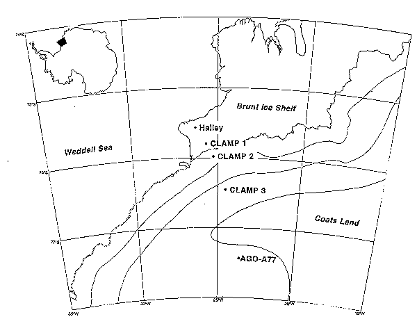 A map showing the station locations