David G. Vaughan1, Jonathan L. Bamber2, Mario Giovinetto3, Jonathan Russell4, and A.
Paul R. Cooper1.
An accurate assessment of the overall mass balance of the Antarctic Ice Sheet (Figure 1) is
crucial to the attribution of recent sea level rise and reliable predictions of future sea level
rise. A more detailed understanding of the pattern of net surface balance is a primary tool
for developing numerical weather prediction and climate models that include Antarctica.
This paper describes an updated assessment of surface balance over Antarctica that uses
recent in situ measurements of surface balance and advances in technique. A new elevation
model of Antarctica derived from ERS-1 satellite altimetry supplemented with conventional
data, was used to delineate the ice flow drainage basins across Antarctica. The areas of
these basins were calculated using the recent digital descriptions of coastlines and
grounding lines. The delineation of drainage basins was achieved using an automatic
procedure, which gave similar results to earlier hand-drawn catchment basins. More than
1800 published and unpublished in situ measurements of net surface balance from
Antarctica were collated and then interpolated. A surface balance map derived from passive
microwave satellite data, being employed as a forcing field to control the interpolation of
the sparse in situ observations. Basin-wide integrals of net surface balance were calculated
using tools available within a Geographical Information System. It is found that the
integrated net surface balance over the coterminous grounded ice sheet is 1810 Gt a-1, and
over the entire continent (including ice shelves and their embedded ice rises) it is 2288 Gt a-1.
These values are 18% and 7% higher than the estimates widely adopted at present. The
uncertainty in these values is hard to estimate from the methodology alone, but the
progression of estimates from early studies to the present suggests that around 5%
uncertainty remains in the overall values. The results serve to confirm the great uncertainty
in the overall contribution of the Antarctic Ice Sheet to recent and future global sea level
rise even without a substantial collapse of the West Antarctic Ice Sheet.
Snowfall from clouds and clear skies, the formation of hoarfrost at the surface and within
the snowpack, sublimation, melting and runoff, wind scouring and drift snow deposition, all
contribute to solid, liquid and gaseous water transfer across the surface of the Antarctic Ice
Sheet. While the measurement of any one of these processes is still a difficult proposition
(King and Turner, 1997, p. 16), the net surface balance, the aggregate of them all, is
measurable by a variety of glaciological techniques.
A precise evaluation of the amount and pattern of net surface balance over the Antarctic Ice
Sheet will confer benefit on many active areas of research including; the selection of ice
coring sites before drilling (Clausen et al., 1988), comparison with poleward atmospheric
moisture transport (Bromwich, 1990), the validation of weather and climate models (Tzeng
et al., 1993; Connolly and Cattle, 1994; Genthon, 1994; Genthon and Braun, 1995;
Connolley and King, 1996; Ohmura and Wild, 1996; Starley and Pollard, 1997) and
investigations of ice flow (Fastook and Prentice, 1994, Huybrechts, 1994; Budd and
Warner, 1996).
Recent studies have shown distinct small-scale spatial variability in net surface balance over
the Antarctic Ice Sheet (Richardson, 1997; Isaksson et al., 1996), while others have revealed
temporal trends in net surface balance that are both positive (Peel, 1992; Goodwin, 1991;
Morgan et al., 1991; Jouzel et al., 1983; Petit et al., 1982) and negative (Isaksson et al.,
1996). Considered in isolation these studies could be taken to suggest that an attempt to
draw a synoptic map of net surface balance for the continent might be unsound. This is,
however, only true over a small-scale, and we proceed on the premise that there exist
broad-scale, persistent patterns of net surface balance that can be mapped at a continental scale, in
the same way that; for example, rainfall can be mapped across continental-scale areas
without discounting the possibility of local variations and temporal trends.
Continent-wide maps of net surface balance have traditionally been compiled from in situ
measurements of net surface balance from pits and cores. More data have been added to
these maps as they have been collected, so that the maps of net surface balance have become
progressively more detailed, and presumably more accurate, accepting the proviso that the
data have been derived over progressively longer periods. In the last four decades at least
22 such compilations have been presented. The most significant reassessments have been
presented at approximately 10-year intervals; Kotlyakov (1961), Bull (1971) and
Giovinetto and Bentley (1985). Giovinetto and Bull (1987) showed that the mean net
surface balance calculated for each these compilations were generally converging, although
considerable scatter persists. The last significant reassessment (Giovinetto and Bentley,
1985) can now be updated with more in situ measurements and more reliable methods of
analysis. Thus this paper continues the process of reassessment, but introduces several
improvements:
a. A new topographic model of the ice sheet that defines the pattern of flow and the drainage
basins more accurately.
b. An updated compilation of in situ measurements that gives improved resolution in the net
surface balance map.
c. The use of an independent background field controls the interpolation between sparse in
situ measurements.
d. Improved techniques of basin-wide integration within a Geographic Information System
(GIS) that removes the uncertainty introduced by manual analysis.
This study is based on a digital elevation model (DEM) of Antarctica previously presented
and discussed by Bamber (1994) and Bamber and Huybrechts (1996). For most of the
continent, the DEM was derived from more than 20 000 000 measurements of surface
elevation retrieved from the eight 35-day repeat cycles of the ERS-1 satellite radar altimeter.
Over areas where slopes are less than 0.5ø, the vertical accuracy is better than ñ1 metre. In
areas of higher surface slope, accuracy is reduced. Around the coast and in mountainous
areas where the altimeter failed to maintain track on the ice sheet surface, the altimeter
measurements were supplemented with data taken from the Antarctic Digital Database
(ADD) (SCAR, 1993; Thompson and Cooper, 1993). Beyond the orbital limit of ERS-1,
south of 81.5øS, data from the Scott Polar Research Institute Folio Series (Drewry, 1983)
and data from the original airborne radar sounding flights have been used. In some areas the
only data available were collected during the Tropical Wind Energy Conversion Reference
Level Experiment (TWERLE) 1975-76 (Levanon et al., 1977; Levanon, 1982).
All these data were gridded to 10 km resolution using methods described by Bamber and
Huybrechts (1996). Throughout the paper this DEM will be referred to as the Observed
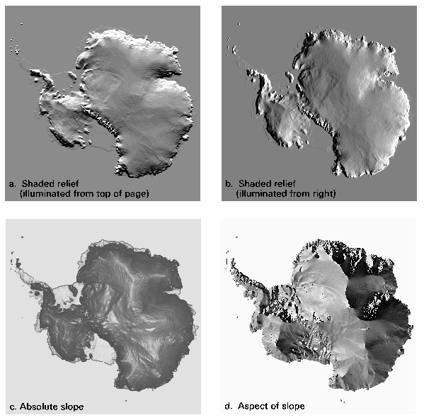
DEM. Figure 2. presents the Observed DEM as a series of images designed to highlight
complementary aspects of the topography. The two shaded-relief maps (Figure 2a and 2b)
give an impression of the overall shape of the ice sheet, while the map showing magnitude
of surface slope (Figure 2c) highlights flatter areas such as ridges, domes and subglacial
lakes. Finally, Figure 2d shows the direction of maximum slope and serves to highlight the
exact position of the ice divides and ridges.
In common with all glaciers, ice flow within the Antarctic Ice Sheet is driven by stresses
generated as the result of surface and basal slopes. For most of the Antarctic Ice Sheet, the
stress resulting from the surface slope is dominant (Paterson, p. 241) and the flow of the ice
sheet is generally parallel to the direction of maximum surface slope, or aspect. Exceptions
to this rule will be discussed in a later section. This reasoning was first used to determine
drainage basins by Giovinetto (1964). Drewry (1983) also used this reasoning to plot
flowlines for the entire continent by determining the direction of maximum surface slope on
a grid (111 km resolution) of the best available surface elevation model. From this he drew
the flow vectors by hand. Drewry's contours and flowlines were used by Giovinetto and
Bentley (1985) to determine the catchment areas that feed 26 physiographically distinct
sectors of the coastline of Antarctica. A similar approach was taken by Radok et al. (1986,
1987) based on a computer analysis of a gridded version of the same surface data to produce
a simpler set of drainage basins.
A catchment basin delineation similar to that done by Drewry has been performed for this
study by applying standard hydrological modelling tools available in the proprietary GIS,
ARC/Info (version 7.0), to the Observed DEM. Several steps were required to determine
the drainage pattern.
a. The Observed DEM was made hydrologically consistent by artificially filling any
closed surface depressions (sinks) deeper than 50 m. In practice, this involved the
filling of only one depression within the ice sheet between Hercules Dome and
Horlick Mountains (S 85ø55' W 114ø). This depression was also present in the
DEM shown by BAS (1993), although it is not clear if it represents a real and
unexplained surface depression or is an artifact of the data.
b. For each cell in the Observed DEM the direction of steepest descent (aspect) was
determined by reference to adjacent grid points and a new grid of containing the
aspect generated. Where the descent to all the adjacent cells was the same then the
search was extended until the steepest descent was found. Where the steepest
descent was found for two directions, both directions were recorded (Jenson and
Domingue, 1988). Since no interpolation was allowed only eight primary directions
were allowed.
c. The grid of aspect data was converted to a vector description of the ice flow
trajectories. While the improved resolution of this operation (10 km) over that
achieved by Drewry (111 km) allowed for a considerable improvement in the detail
in the map of flow direction, it was clear that there existed some problems with this
description of the flow. Primarily, there is a mismatch between the area north of
81.5øS for which ERS-1 data were available and that south of this line, for which
only terrestrial, airborne and TWERLE balloon data were available. The derived
flowlines appear to skirt the boundary of this area, indicating some mismatches in
DEM slopes. Furthermore, while the flowlines outside this area have a well formed
dendritic appearance, inside they are parallel over wide areas, indicating that the
sparse data has resulted in unrealistically planar areas.
d. The watershed or basin was defined as the up-slope area contributing to flow across
a defined section of coast and simply calculated from the flow trajectories. The
overall pattern of drainage was controlled by defining sections of grounding line
manually. In the present analysis these sections were defined to be the same as those
used by Giovinetto and Bentley (1985), rather than according to any particular
topographic criterion, allowing direct comparison with the earlier work.
Since the above analysis assumes that ice flow is parallel to the aspect, which is not
necessarily true for floating ice, we have chosen to limit the flow analysis to the grounded
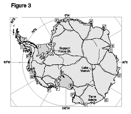
continental ice sheet, and not extend it to the ice shelves. Figure 3 shows the results of the
automatically derived basin delineation procedure.
While the automatic procedure described above provided an adequate delineation of the
drainage basins over most of the ice sheet, there exist two locations where we believe it
needs amending.
Around 64 subglacial lakes have now been identified in Antarctica (Siegert et al., 1996).
They occur mostly under thick ice in East Antarctica and are generally only a few
kilometres in extent. Although, most of the lakes were identified by the characteristically
strong and uniform echoes on ice sounding radar (Oswald and Robin, 1973; Steed, 1980;
McIntyre, 1983), many are also visible as unusually flat areas on surface maps derived from
satellite radar altimetry (Cudlip and McIntyre, 1987; Ridley et al., 1993), showing that
subglacial lakes have a strong influence in the surface topography of the ice sheet. Without
basal restraint, the dynamics of the ice sheet over the lakes is similar to those of a confined
ice shelf; local flow is determined by the local strainrate and ice velocity around the
margins. Such behaviour could disrupt our determination of ice divides over the lakes.
Fortunately, most of the lakes have dimensions similar to the ice thickness (Siegert et al.,
1996). This is smaller than the present grid resolution, and so they are unlikely to disrupt
the determination ice divide position. There are two possible exceptions, Lake Vostok (241
x 43 km, Kapitsa et al., 1996) and the 30 km lake in Terre Adelie, identified by Cudlip and
McIntyre (1987).
The Terre Adelie lake had little impact on the determination of the catchment basin, as it
lies entirely within one basin. Lake Vostok was, however, bisected by the automatically
derived drainage divide (Figure 3). Only one ice velocity measurement has been made, at
the southern extremity of the lake. From this measurement Kapitsa et al. asserted that ice
flow over the lake was controlled solely by local surface gradient, and thus was parallel to
the long axis of the lake, in agreement with the automatically derived ice divides. We prefer
the interpretation that the flow of ice on the lake is driven largely by ice velocities around its
boundaries, not local strainrate, and that ice flow is generally perpendicular to the axis of the
lake. This implies that we should calculate the basin boundaries ignoring the local
topography over the lake. This line of reasoning has required a manual amendment to the
automatically derived ice divide as shown in Figure 3.
There is an area inland of Support Force Glacier, beyond the limit of ERS1 data, where the
sparsity of data produces a poorly constrained ice divide. In this area we have decided to
edit manually the ice divide to maintain agreement with ice surface contours and form lines
given in the ADD.
Figure 3, shows a direct comparison of the ice drainage basins derived by Giovinetto and
Bentley, 1985 and those derived above. There are no gross differences between the two sets
of drainage basins and most of the divides lie very close to those derived by Giovinetto and
Bentley (1985). In one minor area the Giovinetto and Bentley delineation does seem
questionable; they suggested that four drainage basins adjoined at a single junction near
Dome A. Hindmarsh (1993) has discussed the likelihood of such an event and determined
that it would represent a non-generic, or unlikely random occurrence. In the drainage basin
delineation derived in this study there are no four divide junctions.
Table 1. allows us to make a more detailed comparison based on the areas of the derived
catchment basins. Areas of the derived basins have been calculated with reference to the
1:30 million scale coastline presented in the ADD after reprojection to the Lambert Equal
Area projection. These areas can be compared directly with those calculated by Giovinetto
and Bentley (1985) which are also given in Table 1. As Giovinetto and Bentley used a
different grounding line and measured the area of each drainage basin graphically at 1:10
000 000 scale, correcting for scale distortion in using a single scale-factor, updated
estimates of areas for the Giovinetto and Bentley drainage basins are also listed in Table 1.
These were calculated using the updated grounding line and transformed to Lambert Equal
Area projection.
Clearly, the change in the grounding line and method of calculation has caused some
considerable changes in the areas of the drainage basins. In some cases (eg E"F) this is
largely due to an updated grounding line, while in others (eg C'D) there is some disparity
that is more probably due to improved methodology.
The sums of the areas of the of the basin polygons representing the coterminous grounded
ice sheet ( 12 100 000 km2) agree closely with the area of the single polygon as given in the
ADD. This value is, however, 1.5 % larger than the area of the contiguous continent
calculated from the same data in BAS (1993), 11 900 000 km2. It seems likely that this
discrepancy is the result of the use of an uncorrected polar stereographic correction used in
BAS (1993).
The sum of the areas comprising the coterminous ice sheet, ice shelves and ice rises (13828
km2) agrees to within 0.8% with the figure calculated by Fox and Cooper (1994, 13949
km2). These minor discrepancies result from the use of a generalised coastline in the present
study.
Most of the Antarctic Ice Sheet experiences little surface melting (Zwally and Fiegles,
1994) and there is a general year-on-year accumulation of snow that becomes locked into
the ice-sheet. Two notable exceptions that will be discussed later, are areas of perennially
exposed rock and areas of blue ice. The flux of snow into the ice sheet system at any
geographical point has been termed the net balance by Paterson (1994, p. 28), here we use
the term net surface balance to avoid confusion with ice dynamics effects.
Net surface balance can be measured in situ by a variety of methods in common use;
stratigraphic interpretation of the layers seen in snow pits and shallow ice cores (eg Alley
and Bentley, 1988); the burial of single stakes and farm of stakes (eg Goodwin et al., 1994);
counting the annual layers in ice cores using some seasonally varying chemical marker,
such as oxygen isotope analysis (eg Reinwarth et al., 1985) and finding the beta-radioactivity
that is a marker of the snow deposited during above-ground testing of nuclear
weapons (eg Whillans and Bindschadler, 1988). Each method has its own strength and
weakness and likely error limits, although, as noted throughout the literature (eg. Giovinetto
et al., 1989) those based on stratigraphic interpretations alone should be considered as the
least reliable method.
For the purposes of this study we assume that the mechanisms of accumulation and ablation
are unimportant, we simply require the total net surface balance. We shall assume, unless
otherwise specified, that in situ measurements of net surface balance can be taken as
regionally and temporally representative. In future, increasing spatial and temporal
resolution of data will highlight geographic and temporal variability, but for the present we
are content to consider only in broadscale geographic variability. We are, however, mindful
of results that do suggest recent changes in the net surface balance at particular sites (eg.
Morgan et al., 1991, Moseley-Thompson et al., 1995).
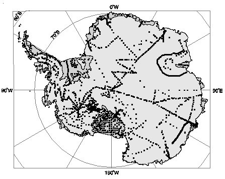
A compilation of in situ measurements of net surface balance containing a total of 1860
points has been established for this study (Figure 4.) and is reported in full by Vaughan and
Russell (1997). For the vast majority of these measurements an original reference has been
found in the literature and is recorded alongside the observation in the compilation.
Around 360 points have, however, been drawn without checking from earlier compilations,
notably Bull (1971). Estimates of uncertainty were given for around 10% of the
measurements, and the period of the observation is known for 30%. Occasionally where
measurements were made densely in some specific locality or along a traverse route the data
have been consolidated.
It should be noted that there are many areas across the Antarctic Ice Sheet where the net
accumulation is zero or significant ablation causes the net surface balance to be negative.
These are areas of bare-ice (blue-ice) and areas of rock outcrop.
The boundary around an area of blue ice, although variable from year-to-year, is an isopleth
of zero net surface balance. Inclusion in the database is not however straightforward as
there are many hundreds of isolated bare-ice areas and there is no single source for the
location and extent of such areas over the continent. The meteorological conditions that
cause bare-ice fields are generally local, and so a bare-ice area should not be considered as
having a wide influence on the regional net balance. Indeed, Bintanja and van den Broeke
(1995) noted that while blue ice areas are widespread, "their surface area is too small to play
an important role in the total surface mass balance regime of Antarctica". For these reasons
we have decided not to make a correction to the estimates of net surface balance for most of
the areas of blue ice.
The exception to this, is Lambert Glacier where several authors have noted that there is an
extensive area of blue ice and zero net accumulation. McIntyre (1985) identified this area
using satellite imagery and measured its extent as 56 000 km2, or 4% of the area of basin BC
as measured in this study. The 0 kg m-2 a-1 isopleth given by Higham and Craven (1997) has
thus been taken as an accurate delineation of the blue ice area, and we have used this
contour as an additional constraint during gridding and contouring of the data.
A correction for the area of exposed rock is more simply calculated and is discussed in
section 5a.
Giovinetto and Bentley (1985) made corrections for deflation (where snow that falls on a
steep slope near the sea and is blown into the sea and lost from the ice sheet) and ablation
(areas in the coastal zone that suffer net ablation), based on a discussion by Giovinetto
(1964). Determination of the size of these corrections was largely arbitrary and is not
considered adopted for the current study.
A single overriding problem in any attempt to draw contours of net surface balance over
Antarctica from in situ net surface balance measurements is that the data are unevenly
distributed and too sparse to produce a reasonable contouring without significant manual
intervention. Large parts of the continent have not been sampled while other areas that lie
along traverse routes with a high density of points. A simple minded automatic contouring
of the data would make little sense when considered in terms of the known topography of
the continent. There are insufficient points to resolve the higher frequency spatial variations
in net surface balance. Thus far maps have been drawn by hand to be consistent with
particular features of the continent thought to be important. Giovinetto and Bull (1987)
summarised these factors as; surface elevation and slope, assumed surface air drainage,
direction of incoming lower-tropospheric flow, distance from the coast and the distance to
the seasonal sea-ice edge and polynyas.
One method to improve the interpolation of the sparse net surface balance data is to use
another background field to guide the contouring in areas of insufficient data. This approach
was suggested by Giovinetto and Bull (1987) who suggested that microwave emission data
had been shown to correlate with net surface balance (Zwally, 1977; Rotman et al., 1982,
Doake, 1985; Thomas et al., 1985) and would eventually provide useful control for this
purpose. This is precisely the approach that we will eventually adopt for the present study,
although first some alternatives were considered.
Clearly, to be useful, a background field introduced to control the contouring of sparse data
should be highly correlated with the parameter to be contoured. It should have adequate
coverage and resolution and be derived from data independent from that which is to be
contoured. Several candidate fields were considered
Fortuin and Oerlemans (1990) looked for correlations between net surface balance and
saturated vapour pressure of the free atmosphere above the inversion (SVP), the surface
slope and the surface convexity. They found no significant correlations over the entire
continent, but found a significant correlation with SVP and surface convexity over the
interior of East Antarctica. A similar exercise was performed to determine the usefulness of
various fields as background fields for forcing our contouring of net surface balance.
Values were extracted from each of the candidate fields at positions where in situ net
surface balance measurements are available. A linear correlation was performed on the
observed net surface balance and the extracted values. Table 2. shows the results of this
exercise for several candidate fields.
The best correlation was obtained using the map of accumulation (MBz) produced using the
firn emissivity method (Zwally, 1977). Applying a single hyperbolic function to all
Antarctica (using hyperbolic coefficients a0 = -5.5, and a1 = 6.50; similar to those used by
Zwally and Giovinetto, 1995). It should be noted that the hyperbolic coefficients were
derived with reference to in situ measurements of net surface balance at 367 sites selected
for their reliability but which included stratigraphic determinations of balance supported by
stake measurements at one or more sites along traverse routes. While the single hyperbolic
function showed robust correlation between the surface data and the emissivity derived
values (r2 = 0.82) it gave relatively high residuals (RMS = 90 kg m-2 a-1). These high
residuals led Zwally and Giovinetto (1995) to adopt two hyperbolic functions with different
sets of hyperbolic coefficients based on in situ measurements using only stable-isotope or
radioactive-isotope methods. The approach reduced the number of data sites (82 in East
Antarctica, 69 in West Antarctica) but improved the fit between the in situ data and the
emissivity derived values. Nevertheless, because the net surface balance values for the sites
compiled for the present study includes all measurement techniques, we use a map based on
the single hyperbolic function.
It should be noted that by not using the fields generated by climate models we have avoided
contamination of the final net surface balance map that would exclude its use for testing
such models in future. The least squares regression of the values of in situ net surface
balance measurements, MBobs, against coincident values of MBz is given by
The correlation coefficient (r= 0.46) and standard deviation of the residuals (ñ131 kg m-2 a-1)
for this relation indicates that while MBz does represent much of the variation in field
observations, it cannot be considered to represent all of it, as estimates of uncertainty given
in the original publications have a mean of ñ52 kg m-2 a-1. This is further confirmed by
considering the areal distribution of the residuals which shows a reasonably coherent pattern
across the ice sheet, with extended areas of positive residuals exceeding 200 kg m-2 a-1, for
example along the Bryan Coast and west coast of the Antarctic Peninsula; and areas of
negative residuals exceeding -200 kg m-2 a-1, for example along the Amundsen Sea Coast.
Giovinetto et al. (1989) described in some detail the technique they used to produce a
contour map of net surface balance (Giovinetto and Bentley, 1985) by choosing between
apparently disagreeing datasets. In summary, where they were suspicious about the
apparent mismatch between nearby or overlapping data, they generally rejected
measurements obtained by stratigraphic methods alone.
In this regard a relevant analysis comes about by comparing the residuals (MBobs-MBz) of
subsets of the data used in this study (Table 3.). Data from the early compilation by Bull
(1971), which contained many observations from stratigraphic data, has lower RMS
mismatch from the Zwally accumulation field (MBz) than either, the dataset used by Zwally
and Giovinetto (1995) which contained no stratigraphically derived data, or other data
published since 1985 which also included few stratigraphically derived points. Making the
general assumption that the stratigraphically derived data are per se unreliable thus seems
unrealistic. Bearing this in mind we have chosen not to make arbitrary choices between
datasets but to include all the data, except where the (MBobs-MBz) residuals for a single or
small group of points are unbelievably large (see Step - 2 below).
Having accepted the MBz field as the best available forcing field, the derivation of the final
net surface balance grid and map has proceeded through several steps:
Step 1 Subtraction of MBz field scaled using (2) from observed net surface balance (MBobs)
to yield values of residuals at the observation sites.
Step 2 Manual editing and removal of a handful of suspect isolated points that appear to
show unfeasibly large residuals (>200 kg m-2 a-1). Editing data such that
observations with very low residuals (less than 20 kg m-2 a-1) are put to zero.
Step 3 Imposition of further constraints on the contouring of residuals. Mountain ranges
are represented by discontinuities (faults), and major ice divides and ridges are
represented by sharp changes in gradient in the residual field.
Step 4 Gridding of residual values using Delauney triangulation with the other constraints
applied.
Step 5 Addition of gridded residual file to the Zwally accumulation field (MBz) scaled
using (2) to reconstruct the net surface balance grid.
Step 6 Editing to fix areas of negative net surface balance to zero and smooth the derived
grid over 30 km.
Step 7 Contours were drawn for the gridded data and then smoothed using a Douglas-Peuker
filter to remove contour deviations smaller than the pixel size (10 km).
The final map of net surface balance for the entire continent including ice shelves is shown
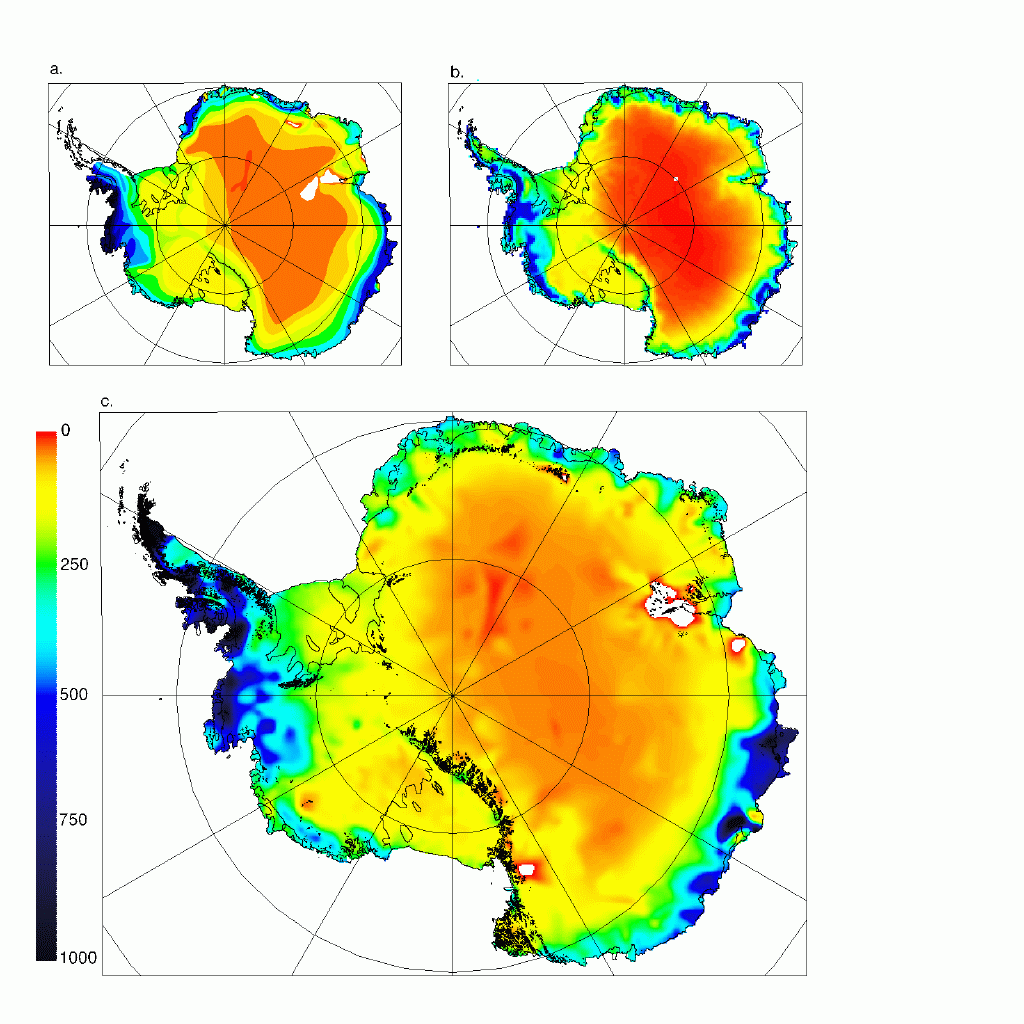
in Figure 5c.
In general terms, Figure 5. shows that the present compilation has the same broadscale
pattern of net surface balance variations as that presented by Giovinetto and Bentley (1985).
There are, however, some significant differences, the central desert in East Antarctica (as
defined by the 50 kg m-2 a-1 contour) is smaller in the present representation. The Filchner-Ronne
and Ross ice shelves show a less pronounced minimum of net surface balance. More
spatial variability is evident in the coastal regions around the whole continent.
Giovinetto and Bentley (1985) estimated the total net surface balance for each basin directly
from the isopleth map, using manual procedures to convert the areas contained between the
isopleth lines to evaluate net surface balance. Where the rate of change of balance between
isopleths is not linear, these techniques will give biased values. With the application of
modern GIS techniques to calculate integrals as the summation of values at gridpoints, here
at 10 km spacing, these limitations can be largely overcome.
Table 4 shows the results of the basin-wide integration of the net surface balance
distribution shown in Figure 5c and the basins delineations shown in Figure 3. For the area
II" (Antarctic Peninsula) the value calculated by Frolich (1992) has been used. Frolich
made this calculation at higher resolution and precision than is obtainable here. The
comparable values calculated by Giovinetto and Bentley (1985) are also included in Table
4. The present determination shows the mean net surface balance rates for most basins are
higher than those estimated by Giovinetto and Bentley (1985).
Since areas of permanent rock outcrop are areas of zero net surface balance, the integrations
performed above should be corrected for the area of rock outcrop. The total area of rock
outcrops that are shown in a 1:3 000 000 generalisation of the Antarctic Digital Database
forms a useful basis for calculation. It includes a total of around 11 000 outcrops, of which
around 10 000 lie on the coterminous continent. For each of these outcrops a value of the
net surface balance at the centroid of the outcrop polygon was extracted from the grid
derived above. This is an adequate approximation as all the outcrop polygons are smaller
than the grid cell size. The total area of the generalised outcrops is 98 000 km2, and the
accumulated net surface balance is 30 x 1012 kg a-1. In this way, the total area is
over-estimated since the outcrops polygons used are generalised from the original polygons
which had a total area of 48 000 km2 (BAS, 1993). To account for this, the accumulated net
surface balance has been reduced accordingly. The correction for the total net surface
balance for Antarctica (given in Table 4.) due to the zero mass balance over rock outcrops is
thus -14.8 x 10¹² kg a -1.
Since most of the numerical calculations are now done digitally using relatively fine grids
there is little reason to suspect systematic errors in either the calculation of basin areas or
the integration of the net surface balance field over these areas. We estimate that together
these numerical errors are likely to account for no more than a 1% error in the final basin
integrals.
The dominant uncertainty continues to arise in the gridding process. Since there is some
manual intervention in the procedure an objective measure of the uncertainty in final
compilation cannot be directly obtained from a consideration of the methodology. An
estimate of the uncertainty must be made by other means.
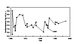
The progression of mean net surface balance estimates described by Giovinetto and Bull
(Table 2, 1987) and other sources are shown in Figure 6 with a comparable value from this
analysis. Since most in situ measurements were used in more than one study, the
progression of the estimates of mean net surface balance may give some indication of the
uncertainty in the method. In a general sense the mean net surface balance is converging
towards a more uniform value. This can be seen in the reduction of standard deviations from
the mean in each decade, 2.4 kg m-2 a-1 (1960s), 0.5 kg m-2 a-1 (1970s), 1.0 kg m-2 a-1 (1980s)
and 0.4 kg m-2 a-1 (1990s). The spread of estimates since Giovinetto and Bentley (1985)
suggests a likely uncertainty of around ñ5%.
This paper presents a compilation and interpretation of data to assess the net surface balance
of the Antarctic Ice Sheet. Besides updating the body of in situ measurements, this study
introduces several important refinements to the method that improve both reliability and
repeatability: basin delineation using automated techniques on an improved DEM, digital
calculation of surface areas and basin-wide integrations, interpolation of sparse data using
an independent background field. The results indicate a total net surface balance for the
coterminous grounded ice sheet as 1734 Gt m-2 a-1 and for the entire ice sheet including ice
shelves and embedded ice rises, 2288 Gt m-2 a-1. While the uncertainty is difficult to
calculate systematically, a comparison to earlier compilations suggests that an uncertainty of
at least ñ5%.
The total net surface balance calculated in this value represents an increase of 15% (20% for
the contiguous grounded ice sheet) above the estimate mostly widely used until now
(Giovinetto and Bentley, 1985). Indeed, it is more in line with other estimates published
before Giovinetto and Bentley (1985); whose estimate was 8% lower than the mean of 12
earlier estimates (Jacobs et al., 1992). This is a surprising result since Giovinetto and
Bentley (1985) stated that while "the surface balance isopleth pattern...is likely to change as
additional data become available...we believe that the changes will not be large enough to
alter the total and mean balance rates by more that a few percent in most of the systems...".
A change in the estimated total net surface balance of the Antarctic Ice Sheet clearly has
direct implications for the attribution of measured sea level change. Jacobs et al. (1992)
stated that each millimetre of sea-level rise is roughly equivalent to the addition of 360 Gt of
water to the world's oceans. This implies that the accumulation of ice falling on the
grounded ice sheet is thus equivalent to 4.8 mm of sea level each year. Jacobs et al. (1992)
estimate the total mass of ice lost from the ice sheet (including ice shelves) to be 2613 Gt a-1.
They compared this with the total net surface balance for the continent given by
Giovinetto and Bentley (1985) and Frolich (1992) and calculated a net imbalance of (-469 ñ
639 ) Gt a-1. Using the estimates from the present study, (2288 ñ 114) Gt a-1, we can refine
this estimate of net imbalance to (-325 ñ 594 Gt a-1). In terms of uncertainty, this is only a
small improvement and we are still unable to determine even the sign of the contribution of
the Antarctic Ice Sheet to recent sea level change. But it is now clear that the major
uncertainty resides in the determination of the attrition components and not the
accumulation components.
These calculations perhaps highlight a disturbing truth for those engaged in the effort of
attributing observed sea level rise to its contributing sources. Only a simple calculation is
required to show that a massive reduction in the uncertainties in the attrition components
will be required before a useful attribution is possible. Warrick et al. (1995) give the best
estimate for sea level rise over the last century as 18 cm, or a yearly addition of around 650
Gt of water, which is roughly equal to the uncertainty in the yearly surface balance of
Antarctica. If the present method of evaluation is ever to allow determination of the
contribution of the Antarctic Ice Sheet to sea level that has an uncertainty of less than 10%
of the observed sea level trend, both accumulation and attrition terms must be calculated to
an uncertainty of around 1-2 %. This is unlikely to be feasible with present methods. It is
most probable that significant progress in this direction will come not by reducing
uncertainty in net surface balance and attrition components, but by the direct measurement
of the difference between these values using satellite altimetry of the ice sheet surface
(Zwally et al., 1989). Meanwhile the study described here will, perhaps, be of greatest
value to researchers involved in the validation and tuning of numerical weather prediction
and climate models.
We thank S. R. Jordan who pointed out several sources of
accumulation measurement. H. J. Zwally who provided the SMMR derived accumulation
field and C. S. M. Doake, E. M. Morris who provided useful discussions.
Alley, R. B. and C. R. Bentley, 1988: Ice-core analysis on the Siple Coast of West
Antarctica. Ann. Glaciol., 11, 1-7.
Bamber, J. L., 1994: A digital elevation model of the Antarctic Ice Sheet derived from the
ERS-1 altimeter data and comparison with terrestrial measurements. Ann. Glaciol., 20, 48-54.
Bamber, J. L. and P. Huybrechts, 1996: Geometric boundary conditions for modelling the
velocity field of the Antarctic Ice Sheet. Ann. Glaciol., 23. 364-373.
Bintanja, R., and M. R. van den Broeke, 1995: The surface energy balance of Antarctic
snow and blue ice. J. App. Meteor., 34 (4) 902-926.
British Antarctic Survey, 1993: Antarctica - a topographic database. 1:10 000 000 scale
map, BAS (Misc.) 7. Cambridge, British Antarctic Survey.
Bromwich, D. H., 1990: Estimates of Antarctic precipitation. Nature, 343, 627-629.
Budd, W. F. and R. C. Warner, 1996: A computer scheme for rapid calculations of balance-flux distributions. Ann. Glaciol., 23. 21-27.
Bull, C., 1971. Snow accumulation in Antarctica: Research in the Antarctic, American
Association for the Advancement of Science. 367-421.
Clausen, H. B., N. S. Gundestrup, S. J. Johnsen, R. Bindschadler and J. Zwally, 1988:
Glaciological investigations in the Cr�te area, central Greenland: a search for a new deep-drilling site. Ann. Glaciol., 10, 10-15.
Connolley, W. M. C. and J. C. King, 1996: A modeling and observational study of East
Antarctic surface mass balance. J. Geophys. Res., 101 (D1), 1335-1343.
Connolley, W. M. C., and H. Cattle, 1994: The Antarctic climate of the UKMO Unified
Model. Ant. Sci., 6 (1), 115-122.
Cudlip, W., and N. F. McIntyre, 1987: Seasat altimeter observations of an Antarctic
"lake". Ann. Glaciol., 9: 55-59.
Doake, C. S. M., 1985: Antarctic mass balance: glaciological evidence from Antarctic
Peninsula and Weddell Sea Sector. Glaciers, Ice Sheets, and Sea Level: Effect of CO2-Induced climatic change,
Rep. 60235-1. US Dept Energy, Washington, DC. 197-209.
Drewry, D. J., 1983: The surface of the Antarctic Ice Sheet. Sheet 2 of Antarctica:
Glaciological and Geophysical Folio, D. J. Drewry, Ed. Scott Polar Research Institute
Cambridge.
Fastook, J. L., M. Prentice, 1994: A finite-element model of Antarctica: sensitivity test for
meteorological mass-balance relationship. J. Glaciol., 40 (134), 167-175.
Fortuin, J. P. F and J. Oerlemans, 1990: Parameterization of the annual surface temperature
and mass balance of Antarctica. Ann. Glaciol., 14, 78-84.
Fox, A. J. and A. P. R. Cooper, 1994: Measured properties of the Antarctic Ice Sheet
derived from the SCAR Antarctic digital database. Polar Rec., 30 (174), 201-206.
Frolich, R. M., 1992: The surface mass balance of the Antarctic Peninsula Ice Sheet. In:
The contribution of the Antarctic Peninsula Ice to sea level rise. Ed. EM Morris. Report for
the Commission of the European Communities Project. EPOC-CT90-0015.
Genthon, C., 1994: Antarctic climate modelling with general circulation models of the
atmosphere. J. Geophys. Res., 99 (D6), 12953-12961.
Genthon, C. and A. Braun, 1995: ECMWF analyses and predictions of the surface climate
of Greenland and Antarctica. J. Climate, 8 (10), 2324-2332.
Gibson, R., P K�llberg and S. Uppala, 1996: The ECMWF Re-Analysis (ERA) project.
ECMWF Newsletter, 73, 7-17.
Giovinetto, M. B., 1964: The drainage systems of Antarctica: Accumulation. Ant. Res.
Ser., 2, 127-155.
Giovinetto, M. B., and C. Bull, 1987: Summary and analyses of surface mass balance
compilations for Antarctica, 1960-1985. Byrd Polar Research Center Report No. 1, pp 90.
Giovinetto, M. B., C. R. Bentley and C. Bull, 1989: Choosing between some incompatible
regional surface-mass-balance data sets in Antarctica. Ant. J. US., 24 (1), 7-13.
Giovinetto, M. B., and C. R. Bentley, 1985: Surface balance in ice drainage systems of
Antarctica. Ant. J. US., 20 (4), 6-13.
Goodwin, I. D., 1991: Snow-accumulation variability from seasonal surface observations
and firn-core stratigraphy, eastern Wilkes Land, Antarctica. J. Glaciol., 37 (127), 383-387.
Goodwin, I. D., M. Higham, I. Allison and R. Jaiwen, 1994. Accumulation variation in
Eastern Kemp Land, Antarctica. Ann. Glaciol., 20, 202-206.
Hindmarsh, R. C. A., 1993: Drainage basin evolution and divide form in Antarctica.
Abstract for The Sixth Symposium for Antarctic Glaciology, Jesus College, Cambridge,
UK. September, 1993.
Higham, M. and M. Craven, 1997. Surface mass balance and snow surface properties from
the Lambert Glacier basin traverses 1990-94. Cooperative Research Centre for the
Antarctic and Southern Ocean Environment, Research Rep. 9. 129 p.
Huybrechts, P., 1994: A numerical study of the response of the Antarctic Ice Sheet to
changes in environmental conditions. In: Belgian Scientific Research on the Antarctic:
Scientific Results Phase 2.Vol. 3. (Ed: S. Caschetto). 1-45.
Isaksson, E., W. Karlen, N. Gundestrup, P. Mayewski, S. Whitlow and M. Twickler, 1996:
A century of accumulation and temperature changes in Dronning Maud Land, Antarctica. J.
Geophys. Res., 101 (D3), 7085-7094.
Jacobs, S. S., H. H. Helmer, C. S. M. Doake, A. Jenkins, R. M. Frolich, 1992: Melting of
ice shelves and the mass balance of Antarctica. J. Glaciol., 38 (130), 375-387.
Jenson, S. K. and J. O. Domingue, 1988: Extracting topographic structure from digital
elevation data for geographic information system analysis. Photogramm. Eng. Rem. Sens.,
54 (11), 1593-1600.
Johns, T. J., R. E. Carnell, J. F. Crossley, J. M. Gregory, J. F. B. Mitchell, C. A. Senior, S.
F. B. Tett and R. A. Wood, 1997: The second Hadley Centre coupled ocean atmosphere
GCM: model description, spinup and validation. Clim. Dyn., 13, 103-134
Jouzel, J., L. Merlivat, J. R. Petit and C. Lorius, 1983: Climatic information over the last
century from a detailed isotopic record in the South Pole snow. J. Geophys. Res., 88 (C4),
2693-2703.
Kapitsa, A., J. K. Ridley, G. de Q. Robin, M. J. Siegert and I. A. Zotikov, 1996: A large
freshwater lake beneath the ice of central East Antarctica. Nature, 381, , 684-686.
King, J. C., and J. Turner, 1997. Antarctic Meteorology and Climatology. Cambridge
University Press, Cambridge. 409.
Kotlyakov, V. M., 1961: The intensity of nourishment of the Antarctic Ice Sheet.
Symposium on Antarctic Glaciology, IASH Publication 55. Int. Assn. Sci. Hydrol.,
Gentbrugge, Belgium. 100-110.
Levanon, N., 1982: Antarctic ice elevation maps from balloon altimetry. Ann. Glaciol., 3,
184-188.
Levanon, N., P. R. Julian and V. E. Suomi, 1977: Antarctic topography from balloons.
Nature, 268 (5620), 514-516.
McIntyre, N. F., 1983: The topography and flow of the Antarctic ice sheet. Unpublished
Ph.D. Thesis, University of Cambridge, U.K.
McIntyre, N. F., 1985: A re-assessment of the mass balance of the Lambert Glacier
drainage basin, Antarctica. J. Glaciol., 31 (107), 35-38.
Morgan, V. I., I. D. Goodwin, D. M. Etheridge and C. W. Wookey, 1991: Evidence from
Antarctic ice cores from recent increases in snow accumulation. Nature, 354 , 58-60.
Moseley-Thompson, E., L. G. Thompson, J. F. Paskievitch, M. Purchet, A. J. Gow, M. E.
Davis and J. Kleiman, 1995: Recent increase in snow accumulation at South Pole. Ann
Glaciol., 21, 131-138.
Ohmura, A., and M. Wild, 1996: A possible change in mass balance of Greenland and
Antarctic ice sheets in the coming century. J. Climate, 9 (9), 2124-2135.
Oswald, G. K. A, and Robin, G. de Q., 1973: lakes beneath the Antarctic Ice Sheet. Nature,
245, 251-254.
Paterson, W. S. B., 1994: The Physics of Glaciers 3rd Edition. Elsevier Science, Oxford.
480 pp.
Peel, D. 1992: Ice core evidence from the Antarctic Peninsula. Climate since A.D. 1500,
RS Bradley and PD Jones, Eds. Routledge, New York.
Petit, J. R., J. Jouzel, M. Pourchet and L. Merlivat, 1982: A detailed study of snow
accumulation and stable isotope content in Dome C (Antarctica). J. Geophys. Res., 87 (C6),
4301-4308.
Radok, U. T. J. Brown, D. Jenssen, I. N. Smith and W. F. Budd, 1986: On the surging
potential of polar ice streams: Part IV Antarctic ice accumulation basins and their main
discharge regions. Dept. of the Environment Rep., DE/ER/60197-5
Radok, U. T. J. Brown, D. Jenssen, I. N. Smith and W. F. Budd, 1987: On the surging
potential of polar ice streams: Part IV Antarctic ice accumulation basins and their main
discharge regions: Addendum, August 1987. Dept. of the Environment Rep., DE/ER/60197-5
Reinwarth, O., W. Graf, W. Stichler, H. Moser and H. Oerter, 1985: Investigations of the
Oxygen-18 content of samples from snow pits and ice cores from the Filchner-Ronne ice
shelvers and Ekstr�m Ice Shelf. Ann. Glaciol., 7, 49-53.
Richardson C., E. Aarholt, S.-E. Hamran, P. Holmlund and E. Isaksson, 1997: Spatial
distribution of snow in western Dronning Maud Land, East Antarctica, mapped by a
ground-based radar. J. Geophys. Res., 102 (B9), 20343-20353.
Ridley, J. K., Cudlip, W. and Laxon, S. W., 1993: Identification of subglacial lakes using
ERS-1 radar altimeter. J. Glaciol., 39 (133), 625-234.
Rotman, S. R., A. D. Fisher and D. H. Staelin, 1982: Inversion for physical characteristics
of snow using passive radiometric observations. J. Glaciol., 30, 377-380.
SCAR, 1993: Antarctic digital database user's guide and reference manual. Scientific
Committee on Antarctic Research, Cambridge. Xi+156pp. (This manual accompanies a
CD-ROM).
Siegert, M. J., J. A. Dowdeswell, M. R. Gorman and N. F. McIntyre, 1996: An inventory of
Antarctic subglacial lakes. Antarct. Sci., 8 (3), 281-286.
Steed, R. H. N., 1980: Geophysical investigations of Wilkes Land, Antarctica. Unpublished
Ph.D. Thesis, University of Cambridge, U.K.
Starley, L. T., and D. Pollard, 1997: Greenland and Antarctic Mass Balances for present
and doubled atmospheric CO2 from the GENESIS Version-2 Global Climate Model. J.
Climate, 10 (5), 871-900.
Thomas, R. H., R. A. Bindschadler, R. L. Cameron, F. D. Carsey, B. Holt, T. J. Hughes, C.
W. M. Swithinbank, I. M. Whillans, and H. J. Zwally, 1985: Satellite remote sensing for ice
sheet research. NASA Tech. Mem. 86233. Washington D.C., 32 p.
Thomson, J. W, and A. P. R. Cooper, 1993. The SCAR Antarctic digital topographic
database. Ant. Sci., 5 (3), 239-244.
Tzeng, R. Y., D. H. Bromwich and T. R. Parish, 1993: Present-day Antarctic climatology of
the NCAR Community Climate Model Version 1*. J. Climate, 6 (2), 205-226.
Vaughan, D. G. and J. Russell, 1997. Compilation of Surface Mass Balance Measurements
in Antarctica. British Antarctic Survey Internal Report, ES4/8/1/1997/1.
Warrick, R. A. C. Le Provost, M. F. Meier, J. Oerlemans and P. L. Woodworth, 1995:
Changes in Sea Level. Climate Change 1995 - the science of climate change, J. T.
Houghton, L. G. Meira Filho, B. A. Callander, N. Harris, A. Kattenberg and K. Maskell,
Eds., Cambridge University Press. 359-406.
Whillans, I. M. and R. A. Bindschadler, 1988: Mass balance of Ice Stream B, West
Antarctica. Ann. Glaciol., 11, 187-193.
Zwally, H. J., 1977: Microwave emissivity and accumulation rate of polar firn. J. Glaciol.,
18, 195-215.
Zwally, H. J., A. C. Brenner, J. A. Major, R. A. Bindschadler and J. G. Marsh, 1989:
Growth of the Greenland Ice Sheet: Measurement. Science, 246, 288-289.
Zwally, H. J. and M. B. Giovinetto, 1995: Accumulation in Antarctica and Greenland
derived from passive-microwave data: a comparison with contoured compilations. Ann.
Glaciol., 21, 123-130.
Zwally, H. J., S. Fiegles, 1994: Extent and duration of Antarctic surface melting. J.
Glaciol., 40 (136), 463-476.
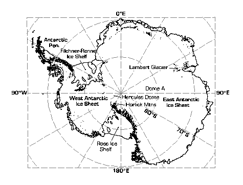
Figure 1. Location map for Antarctica with areas of rock outcrop filled black.
Figure 2. Digital elevation model of Antarctica - the Observed DEM. a. Shaded surface
relief with illumination from top of page. b. Shaded surface relief with
illumination from right side of page c. Shaded to show magnitude of surface
slope, with steeper slopes shaded darker. d. Shaded to show direction of
surface slope.
Figure 3 Delineation of drainage basins according to coastline sectors given by
Giovinetto and Bentley, 1987. Dotted lines indicate those drawn by
Giovinetto and Bentley (1987). Solid lines indicate the drainage basins
derived from the Observed DEM but with manual intervention from the light
dotted line upstream of Support Force Glacier and upstream of Lake Vostok
(shaded white).
Figure 4 Distribution of in situ net surface balance measurements used in this study.
Figure 5 Three maps of net surface balance in Antarctica. a. Giovinetto and Bentley
(1985) compilation based on in situ observations. b. Passive microwave
derived net surface balance field derived by Zwally and Giovinetto (1995).
c. Net surface balance field derived from new compilation of in situ
observation with b. used as a gridding constraint.
Figure 6 The progression of mean net surface balance estimates from 1961 to the
present study. Data prior to 1985 (hatched zone) are taken from the
compilation by Giovinetto and Bull (1987) and post-1985 are from, Radok et
al., (1986,1987), Fortuin and Oerlemans (1990), Warrick and Oerlemans
(1990), Bentley and Giovinetto (1991), Jacobs et al. (1992) and this study.