The following is a detailed description of the data format used for describing BEDMAP data sets. This model is based on a specification for BEDMAP data and metadata drawn up by Ian Allison, Hugh Corr, Janet Thompson and David Vaughan after the first BEDMAP workshop in Cambridge in 1996.
The data contributed to BEDMAP are divided into Missions to allow broad groupings of similar data. The missions will generally consist of data from a single oversnow traverse or series of traverses or a group of sorties/flights for which acquisition parameters remained broadly similar. Typically a mission is viewed as a season of work using a particular set of equipment and procedures. The BEDMAP data archive is stored within an OracleÒ relational database at the British Antarctic Survey, Cambridge, UK. The OracleÒ database consists of two principal tables; the MISSION_DATA table, which contains the actual data, and the MISSION_SUMMARY table, which contains the metadata pertaining to each mission.It was agreed at the first BEDMAP workshop that only final interpreted data sets should be submitted to BEDMAP. Data will be accepted in ASCII format or proprietary formats. Each data file should contain measurements in column format.
The remainder of this document describes the BEDMAP relational database. For further information visit the BEDMAP Web site at;
http://www.nerc-bas.ac.uk/public/aedc/bedmap/bedmap.html
2.0. Database Definition
The relational BEDMAP Database consists of the following tables.
- MISSION_DATA
- MISSION_SUMMARY
- QUALITY
- DATA_TYPE
- NAV_METH
- INSTITUTE
- COUNTRIES
The principal data table in BEDMAP. A single unique row or record describes each point measurement of ice thickness. A total of eleven fields are used to describe the observations (RECORD_ID, MISSION_ID, SORTIE_ID, LATITUDE, LONGITUDE, ICE THICKNESS, SURFACE_ELEV, WATERCOLUMN, BED_ELEV, REFERENCE1, REFERENCE2).
The principal metadata table containing information from each mission. Each mission has a unique record describing methods in data collection, navigation, data logging, processing, source contacts and availability.
Table flagging those observations, which have failed at least one of the quality control checks for spatial correlation. The success or failure at each test is recorded.
Look up table containing definition of the data types used to categorise the ice thickness measurements, e.g. airborne radio echo sounding, seismic, gravimetric, borehole.
Look up table containing definition of the navigation methods used to locate the ice thickness data measurements, e.g. local fix, dead reckoning, doppler satellite positioning, GPS.
Look up table containing name and contact details for all institutes and relevant personnel who have contributed data to BEDMAP (principal investigators).
Look up table referencing the two character country codes used in the INSTITUTES table to the full country names.
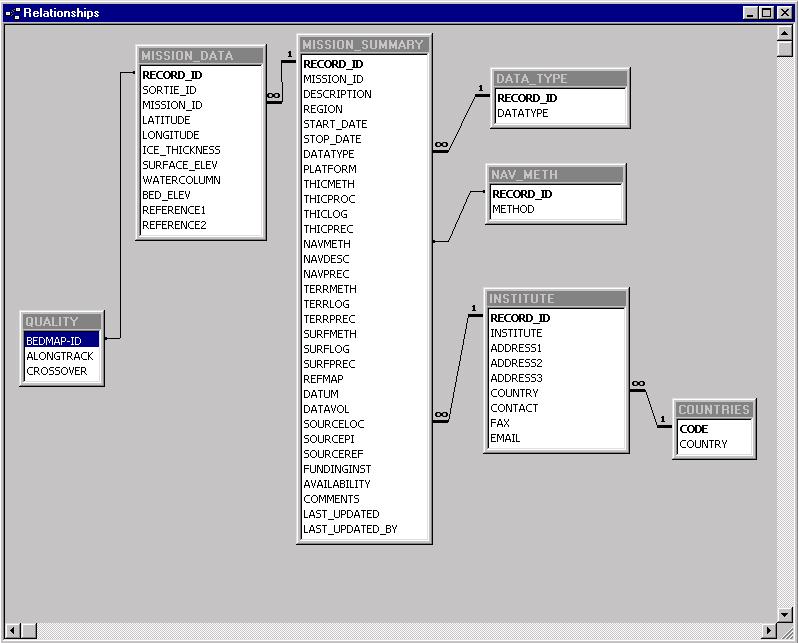
The MISSION_DATA and MISSION_SUMMARY tables are the principal tables used to store the ice thickness data and metadata. The QUALITY table is used primarily to flag potentially anomalous data points. Note: these points are not removed from the database as they may prove to be not be able to be adjusted or refixed in the future. The remaining tables are reference or look up tables used within the relational database to reduce duplication. The DATA_TYPE, NAV_METH AND INSTITUTE tables are referenced to the MISSION_SUMMARY table using a one-to-many relationship while the COUNTRIES table is linked to the INSTITUTES table also using a one-to-many relationship. The relationships between these tables in the BEDMAP Database is presented in schematic format below.
3.0. Entity Relationship Diagram for BEDMAP Database
|
Field |
Type |
Field Width |
Description |
|
RECORD_ID |
INT |
7 |
Mandatory field. Record number identifying point based measurement of ice thickness. Primary key (unique) to data record. Main bedmap id. |
|
SORTIE_ID * |
CHAR |
15 |
Applicable only to trackline or traverse data, sortie reference id assigned to sortie within the overall mission. |
|
MISSION_ID * |
INT |
3 |
Mandatory field. Mission reference ID number assigned by BEDMAP project. Many to one link to metadata table 'MISSION_SUMMARY' |
|
LATITUDE |
FLOAT |
3.5 |
Mandatory field. Latitude of measurement, decimal degrees, all values -ve for southern hemisphere |
|
LONGITUDE |
FLOAT |
4.5 |
Mandatory field. Longitude of measurement, decimal degrees, +ve East, -ve West |
|
ICE_THICKNESS |
INT |
4 |
Mandatory field. Measured ice thickness / m. (Value of -9999 applied to Null values) |
|
SURFACE_ELEV |
INT |
4 |
Measured surface elevation / m - If surface elevation was measured in conjunction with ice thickness it will be included here. (Value of -9999 applied to Null values) |
|
WATERCOLUMN |
INT |
4 |
Thickness of watercolumn / m, determined from seismic or drilled measurements. (Value of -9999 applied to Null values) |
|
BEDROCK_ELEV |
INT |
4 |
Elevation of bedrock / m, determined from ice thickness and surface elevation measurements. (Value of -9999 applied to Null values) |
|
REFERENCE1 |
CHAR |
20 |
Optional field. Reference code used by data providers e.g. Time, Distance, Cane, Terrain clearance |
|
REFERENCE2 |
CHAR |
20 |
Optional field. Additional reference code used by data providers e.g. Time, Distance, Cane. |
CHAR - text, INT - Integer, FLOAT - Floating point.
* Indicates this field is a link to another table (See Entity Relationship Diagram for BEDMAP Database)
|
Field |
Type |
Field Width |
Description |
|
|
RECORD_ID |
INT |
7 |
Mandatory field. Record number. Primary key (unique) to data record |
|
|
MISSION_ ID |
CHAR |
20 |
Mandatory field. Mission reference ID assigned by BEDMAP project |
|
|
DESCRIPTION |
LONG |
400 |
Description of the mission |
|
|
REGION |
CHAR |
100 |
Description of the geographical extent of the mission (TransAntarctic Mts, Ross Ice Shelf, Marie Byrd Land) |
|
|
START_DATE |
DATE |
|
Start date of the mission |
|
|
STOP_DATE |
DATE |
|
Stop date of the mission |
|
|
DATATYPE * |
INT |
2 |
Data type - many to one link to DATA_TYPE Table. |
|
|
PLATFORM |
CHAR |
100 |
Description of platform from which measurements were made (eg. Twin Otter Aircraft) |
|
|
THICMETH |
CHAR |
255 |
Method used to obtain ice thickness (eg. Seismic, RES, Gravity, Borehole) |
|
|
THICPROC |
CHAR |
255 |
Description of algorithm used to calculate ice thickness (Including numeric constants) |
|
|
THICLOG |
CHAR |
255 |
Description of data logging methods (Digital, Analogue, 35 mm file etc.) |
|
|
THICPREC |
INT |
4 |
Estimated accuracy of ice thickness measurement / m |
|
|
NAVMETH * |
INT |
2 |
Navigation method - many to one link to NAV_METH Table. |
|
|
NAVDESC |
CHAR |
255 |
Description of navigation methods . |
|
|
NAVPREC |
INT |
4 |
Estimated accuracy of navigation / m |
|
|
TERRMETH |
CHAR |
100 |
Aircraft height about ground / m (Const. pressure, const. terrain clearance, etc.) |
|
|
TERRLOG |
CHAR |
255 |
Description of surface elevation logging methods |
|
|
TERRPREC |
INT |
4 |
Estimated accuracy of surface elevation method / m |
|
|
SURFMETH |
CHAR |
255 |
Description of instrumentation, algorithms, etc. Orthometric or ellipsoidal |
|
|
SURFLOG |
CHAR |
255 |
Description of logging methods for surface |
|
|
SURFPREC |
INT |
4 |
Estimated accuracy of surface elevation data / m |
|
|
DATUM |
INT |
20 |
Ellipsoid to which data are fixed | |
|
REFMAP |
CHAR |
40 |
Map sheet used in fixing etc. |
|
|
DATAVOL |
INT |
7 |
Volume of data (no. of recordings) |
|
|
SOURCELOC * |
INT |
2 |
Institute and person holding the original data or best contact. Many to one link to INSTITUTE TABLE. |
|
|
SOURCE_INST * |
INT |
2 |
Agency(s) responsible for funding/undertaking project. Many to one link to INSTITUTE TABLE. |
|
|
SOURCEPI |
CHAR |
255 |
Information about the Principal investigator who collected these data |
|
|
SOURCEREF |
CHAR |
255 |
References to publications that have discussed these data |
|
|
AVAILABILITY |
CHAR |
100 |
Current availability of data and restrictions placed upon them |
|
|
COMMENTS |
CHAR |
255 |
Other pertinent comments concerning the data or collection procedure. |
|
|
LAST_UPDATED |
DATE |
12 |
Date data last updated in database |
|
|
LAST_UPDATED_BY |
CHAR |
40 |
Information about the person who last updated the mission record(s) in database |
|
CHAR - text, LONG - extended text, INT - Integer, FLOAT - Floating point, DATE - Date (mm-dd-yy)
* Indicates this field is a link to another table (See Entity Relationship Diagram for BEDMAP Database) Note: It is desirable that some system parameters are recorded for each measuring system in the method field.
|
Field |
Type |
Field Width |
Description |
|
RECORD_ID |
INT |
7 |
Mandatory field. Record number referring to point based measurement of ice thickness. Primary key (unique) to data record. Main bedmap id. |
|
CHECK1 |
INT |
1 |
Valid values are 1 or 0. Value set to 1 if observation failed quality control check. Value set to 0 if passed check. |
|
CHECK2 |
INT |
1 |
Valid values are 1 or 0. Value set to 1 if observation failed quality control check. Value set to 0 if passed check. |
|
CHECK3 |
INT |
1 |
Valid values are 1 or 0. Value set to 1 if observation failed quality control check. Value set to 0 if passed check. |
The following tables are look up tables containing reference data. Where the table represents a limited number of records or an option list, the actual table content is presented in addition to the table specification.
|
Field |
Type |
Field Width |
Description |
|
RECORD_ID |
INT |
2 |
Mandatory field. Record number, primary key. |
|
DATATYPE |
CHAR |
20 |
Valid data type reflecting survey method. |
|
RECORD_D |
DATATYPE |
|
1 |
Airborne RES |
|
2 |
Ground-based RES |
|
3 |
Seismic reflection |
|
4 |
Gravimetric measurements |
|
5 |
Seismic reflection & gravity |
|
6 |
Seismic reflection & RES |
|
7 |
Ground-based RES & gravimetric |
|
8 |
Ice core |
|
Field |
Type |
Field Width |
Description |
|
RECORD_ID |
INT |
2 |
Mandatory field. Record number, primary key. |
|
METHOD |
CHAR |
20 |
Navigation method. |
|
RECORD_D |
METHOD |
|
1 |
Local fix |
|
2 |
Dead reckoning |
|
3 |
Astronomic survey |
|
4 |
Inertial |
|
5 |
Doppler satellite positioning |
|
6 |
GPS |
|
7 |
Traditional survey |
|
Field |
Type |
Field Width |
Description |
|
CODE |
CHAR |
2 |
Mandatory field. 2 character standard country code. |
|
COUNTRY |
CHAR |
20 |
Country name |
|
CODE |
COUNTRY |
|
AR |
Argentina |
|
AU |
Australia |
|
BE |
Belgium |
|
CL |
Chile |
|
CN |
China |
|
DE |
Germany |
|
FR |
France |
|
IN |
India |
|
IT |
Italy |
|
JP |
Japan |
|
NL |
Netherlands |
|
NO |
Norway |
|
NZ |
New Zealand |
|
RU |
Russian Federation |
|
SE |
Sweden |
|
UK |
United Kingdom |
|
US |
United States |
|
UY |
Uruguay |
|
ZA
|
South Africa |
|
Field |
Type |
Field Width |
Description |
|
RECORD_ID * |
INT |
3 |
Record number. Primary key (unique) to data record |
|
INSTITUTE |
CHAR |
150 |
Institute name |
|
ADDRESS1 |
CHAR |
50 |
Primary address information |
|
ADDRESS2 |
CHAR |
50 |
Secondary address information |
|
ADDRESS3 |
CHAR |
50 |
Tertiary address information |
|
COUNTRY * |
CHAR |
2 |
Two character country code. Many to one link to COUNTRIES |
|
CONTACT |
CHAR |
50 |
Name of contact person at Institute |
|
FAX |
CHAR |
30 |
Fax number of contact person at Institute |
|
|
CHAR |
35 |
Email address of contact person at Institute |